Property Record
1058 Tullis Rd, Lawrenceville, GA 30043
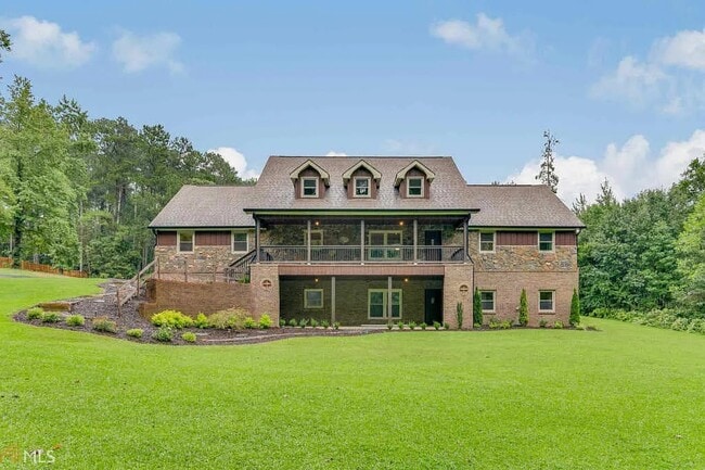


This Property Is For Sale
NEARBY LISTINGS FOR SALE OR LEASE
-
-
View all Lawrenceville listings for sale on LoopNet.com
Property Detail
1058 Tullis Rd
Atlanta-Sandy Springs-Roswell, GA
Tullis Rd
7-024-031
Gwinnett
Sfr
Georgia
X
1.37 AC
13135C0061F
Lawrenceville/Lilburn
5,920 SF
Atlanta
DEMOGRAPHICS near 1058 Tullis Rd
1 Mile
3 Mile
5 Mile
2024 Total Population
6,743
54,743
169,921
2029 Population
7,085
57,461
178,424
Pop Growth 2024-2029
+ 5.07%
+ 4.97%
+ 5.00%
Average Age
39
38
37
2024 Total Households
2,175
16,636
54,051
HH Growth 2024-2029
+ 5.20%
+ 5.11%
+ 5.18%
Median Household Inc
$114,258
$105,910
$94,912
Avg Household Size
3.10
3.20
3.00
2024 Avg HH Vehicles
2.00
2.00
2.00
Median Home Value
$440,287
$402,762
$400,928
Median Year Built
2001
2000
2000
Nearby Places
Map Layers
Map Styles
 Street
 Aerial
- Restaurants
- Banks
- Shops
- Fitness
- Groceries
PUBLIC TRANSPORTATION
AIRPORT
Hartsfield - Jackson Atlanta International
DRIVE
WALK
Distance
Hartsfield - Jackson Atlanta International
62 min
44.9 mi
Nearby Properties
Address
Land Use
TOTAL SIZE
Lot Size
Zoning
Address
Land Use
TOTAL SIZE
Lot Size
Zoning
2,260,742 SF
285.40 AC
M1
Address
Land Use
TOTAL SIZE
Lot Size
Zoning
1,071,116 SF
69.77 AC
OI
Address
Land Use
TOTAL SIZE
Lot Size
Zoning
403,129 SF
126.91 AC
RA200
Address
Land Use
TOTAL SIZE
Lot Size
Zoning
415,609 SF
16.50 AC
RM24
Address
Land Use
TOTAL SIZE
Lot Size
Zoning
190,485 SF
103.66 AC
RA200
Address
Land Use
TOTAL SIZE
Lot Size
Zoning
367,419 SF
17.06 AC
RM24
Address
Land Use
TOTAL SIZE
Lot Size
Zoning
93,022 SF
68.90 AC
R100
Address
Land Use
TOTAL SIZE
Lot Size
Zoning
159,547 SF
24.72 AC
R100
Address
Land Use
TOTAL SIZE
Lot Size
Zoning
233,266 SF
17.39 AC
RA200
Address
Land Use
TOTAL SIZE
Lot Size
Zoning
240,800 SF
28.74 AC
M1
Address
Land Use
TOTAL SIZE
Lot Size
Zoning
250,960 SF
17.55 AC
OI
Address
Land Use
TOTAL SIZE
Lot Size
Zoning
176,034 SF
92.85 AC
RA200
Address
Land Use
TOTAL SIZE
Lot Size
Zoning
101,343 SF
44.33 AC
R1400
Address
Land Use
TOTAL SIZE
Lot Size
Zoning
204,895 SF
26.89 AC
R1200
Address
Land Use
TOTAL SIZE
Lot Size
Zoning
212,571 SF
31.30 AC
RA200
Address
Land Use
TOTAL SIZE
Lot Size
Zoning
149,440 SF
28.41 AC
M1
Address
Land Use
TOTAL SIZE
Lot Size
Zoning
140,240 SF
25.54 AC
R100
Address
Land Use
TOTAL SIZE
Lot Size
Zoning
178,635 SF
28.77 AC
R1200
Address
Land Use
TOTAL SIZE
Lot Size
Zoning
124,425 SF
20.73 AC
RA200
Address
Land Use
TOTAL SIZE
Lot Size
Zoning
140,809 SF
8.97 AC
RM13
Address
Land Use
TOTAL SIZE
Lot Size
Zoning
310,027 SF
18.54 AC
M1
Address
Land Use
TOTAL SIZE
Lot Size
Zoning
393,811 SF
66.81 AC
M1
Address
Land Use
TOTAL SIZE
Lot Size
Zoning
164,850 SF
14.45 AC
M1
Address
Land Use
TOTAL SIZE
Lot Size
Zoning
327,884 SF
19 AC
M1
Address
Land Use
TOTAL SIZE
Lot Size
Zoning
179,065 SF
24 AC
M1
Address
Land Use
TOTAL SIZE
Lot Size
Zoning
110,356 SF
20.42 AC
RA200
Address
Land Use
TOTAL SIZE
Lot Size
Zoning
248,992 SF
17.54 AC
M1
Address
Land Use
TOTAL SIZE
Lot Size
Zoning
97,824 SF
13.71 AC
M1
Address
Land Use
TOTAL SIZE
Lot Size
Zoning
18,200 SF
76.60 AC
M1
Address
Land Use
TOTAL SIZE
Lot Size
Zoning
61,686 SF
10 AC
R1400
The World's #1 Commercial Real Estate Marketplace
Connect with us
© 2026 CoStar Group
The information above has been obtained from sources believed reliable. While we do not doubt its accuracy we have not verified it and make no guarantee, warranty or representation about it. It is your responsibility to independently confirm its accuracy and completeness. Any projections, opinions, assumptions, or estimates used are for example only and do not represent the current or future performance of the property. The value of this transaction to you depends on tax and other factors which should be evaluated by your tax, financial, and legal advisors. You and your advisors should conduct a careful, independent investigation of the property to determine to your satisfaction the suitability of the property for your needs.